Virtual tour, you can navigate through the image with your mouse.
Gemündener Maar Natural Beauty with High Recreational Value
Gemündener Maar, with a diameter of 325 meters, is the smallest of the three Daun Maars. It was named after the Daun district of Gemünden and is located approximately 1.5 kilometers from the district town of Daun. Swimming in the maar is allowed here. There is also an outdoor pool, a large sunbathing area, and boat rental.
Information
- Coordinates: 50° 10´40´´ N / 06°50´11´´ E
- Elevation: 416 m
- Funnel Diameter: 620 m
- Funnel Depth: 117 m
- Lake Diameter: 295 m (N-S) and 319 m (W-E)
- Lake Depth: 39 m
-
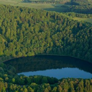
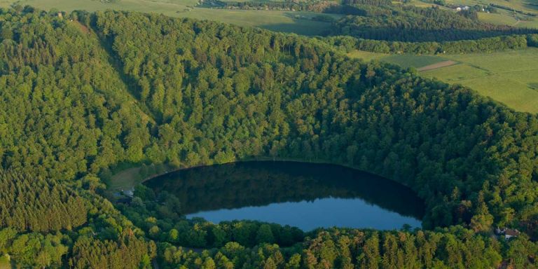
Gemünder Maar von oben © Natur- und Geopark Vulkaneifel GmbH, Kappest
-
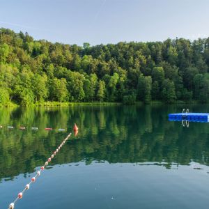
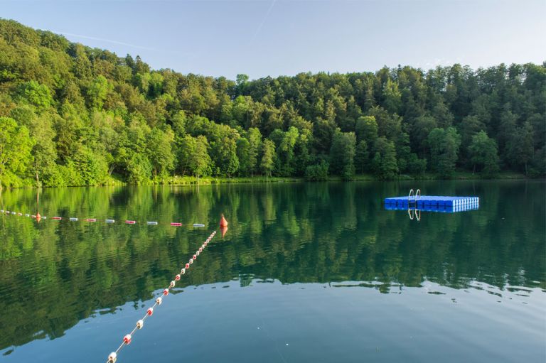
Blick auf die Sprunginsel am Gemündener Maar © Natur- und Geopark Vulkaneifel GmbH, Kappest
Geology
The Schalkenmehrener Maars, the Weinfelder Maar, and the Gemündener Maar are aligned on a fault line running from southeast to northwest and erupted in the following sequence:
- Schalkenmehrener Dry Maar
- S-Flat Marsh
- S-Double Maar
- Gemündener Maar
- Weinfelder Maar
Their formation is estimated to be approximately 20,000 to 30,000 years ago during the Würm Ice Age. The other two Dry Maars and the slag cone Hoher List are even older. The fault line cuts through the following Lower Devonian rock layers from southeast to northwest: first, the Herdorf beds, then the Eckfeld beds, and thirdly, the Reudelsterz beds, indicating the transition from the Siegen stage to the Lower Ems stage.
The older Maars and the slag cone Hoher List are located in the Herdorf beds. These consist of closely folded blue-black shale (Lower Dark Layers), thick sandstone packages (Kürrenberg Sandstone), and sandy shales (Upper Dark Layers). The marine shales and siltstones of the Eckfeld beds are rich in fossils, while the Reudelsterz beds are described as weakly marine to brackish. They consist of poorly sorted sand-siltstones, often with plant remains and coal seams. Maar tuffs often overlay the Lower Devonian rocks in this area.
Location
Gemündener Maar is located in close proximity to the Daun district of Gemünden and 1.5 kilometers south of the district town of Daun. It is the northernmost of the Daun Maars.
Highlights Nearby
- Natural Pool Gemündener Maar
- Weinfelder Maar
- Weinfelder Chapel
- Schalkenmehrener Maar
- Natural Pool Schalkenmehrener Maar
- Lookout Castle Dronketurm
- Daun-Senheld Airfield
- Daun Spa Park
- Dunaris Source
- Hoher List Observatory
- Hotzendrees
- Kurpark Daun
- Eifel Vulcano Museum Daun
Gemündener Maar is Point 27 of the German Volcano Road.
Hiking Trails
Around Gemündener Maar
As in the entire Volcanic Eifel, we invite locals and guests to explore interesting routes around Gemündener Maar. Whether alone or with knowledgeable guidance, explore the region on one of the numerous hiking trails.
Guided Tours Around Gemündener Maar
Directions & Parking
Two parking lots are available to visitors above the maar. Coming from Gemünden on Maarstraße, you will find the first of the two parking lots directly at Waldcafé. If you follow the left road, you will find another parking lot on the road before the outdoor pool with a third parking lot right next to the maar.