Virtual tour; you can navigate through the image using your mouse.
Meerfelder Maar Where Tranquility and Idyll Reign
The Meerfelder Maar is a maar located on the outskirts of the Eifel village of Meerfeld near Manderscheid. The maar lake is nestled within the largest maar crater in the Eifel region. However, only a portion of the 1,700-meter-long basin is covered with water.
In 2008, the Meerfelder Maar was designated as a regional type locality by the International Union of Geological Sciences to define the geological boundary between the Pleistocene and Holocene epochs. The longest sediment core from the Meerfelder Maar measures 45 meters in length, documenting 25,000 years of climate history.
Information
- Coordinates: 50°06'02"N / 6°45'27"E
- Elevation: 335 meters above sea level
- Crater Diameter: 1,730 meters
- Crater Depth: 400 meters
- Crater Age: Approximately 80,000 years (Quaternary)
- Lake Surface Area: 377,000 m2
- Current Lake Depth: Approximately 18 meters
-
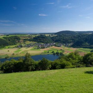
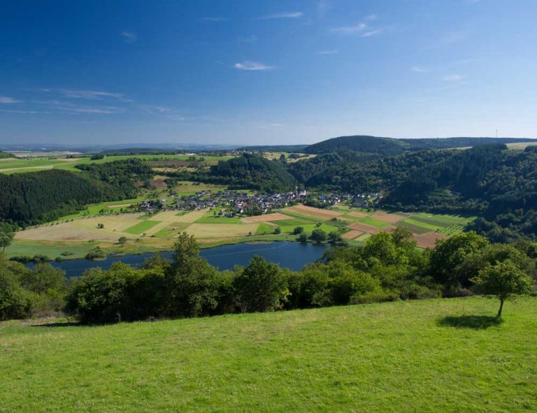
Blick vom Aussichtsturm Landesblick über das Meerfelder Maar © Natur- und Geopark Vulkaneifel GmbH, Kappest
-
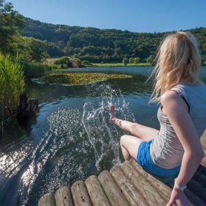
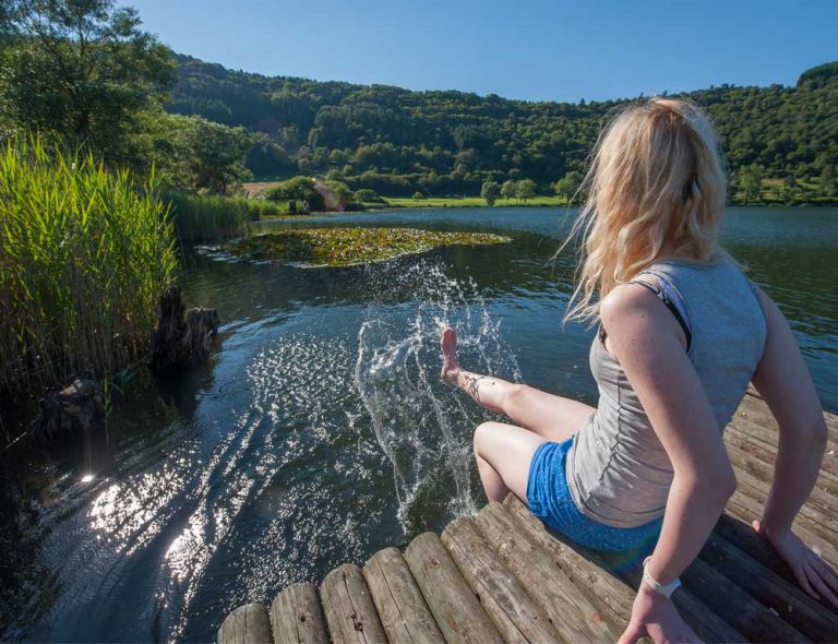
Fußbad am Meerfelder Maar © Natur- und Geopark Vulkaneifel GmbH, Kappest
Geology
The bedrock consists of under-Devonian siltstones, sandstones, graywackes, and quartzites (Eckfeld and Reudelsterz formations) as well as Triassic sandstones (Middle Buntsandstein), which are partially covered by maar tuffs.
How Meerfelder Maar Formed
Where nature now impresses with idyllic tranquility, it wasn't always so welcoming. Over 30,000 years ago, massive explosions created a huge crater in the landscape. Tremendous amounts of ash were ejected, forming a wall with a diameter of 1.7 kilometers, and rocks were hurled kilometers away. Eventually, the volcano calmed down, and over time, rainwater and groundwater collected in the crater, forming a circular lake. At some point, the Meerbach stream managed to breach the crater rim, carrying in sediment and diverting the lake northward. The village of Meerfeld formed on the alluvial fan many thousands of years later, around 1200 AD.
Imperial Generosity
At that time, people in the area made a living from mining and fishing in the Maar lake. They also benefited from highly productive agriculture because volcanic soils provide ideal conditions for plants. They can retain moisture for a long time and are exceptionally nutrient-rich. To expand their cultivation areas, Emperor Wilhelm I gave the people of Meerfeld 12,000 Reichsmarks in 1877. They invested this money in land reclamation. Parts of the maar basin were artificially drained, lowering the lake level by two meters. Today, the lake sits at an elevation of 335 meters above sea level, has a water surface area of 24.8 hectares, and is approximately 18 meters deep.
Location
The Meerfelder Maar is located directly near the small village of Meerfeld, in the vicinity of the town of Manderscheid in the Bernkastel-Wittlich district.
Highlights Nearby
- Volcano Adventure Park Mosenberg
- Observation Tower Landesblick
- Wallender Born "Brubbel"
- Hinkelsmaar
- Windsborn Crater Lake
- Maar Museum Manderscheid
- Manderscheid Castles
- Burberg
The Meerfelder Maar is Point 36 on the German Volcano Road.
Hiking Trails
around Meerfelder Maar
Circular hiking trails with breathtaking views, unobstructed vistas of idyllic Eifel villages, and nature-oriented hikes for those who love tranquility – the hiking trails around Meerfelder Maar will not disappoint.
-

Andere Vulkaneifelpfade Hinterbüsch-Pfad
Von Üdersdorf nach Meerfeld
- Schwierigkeitsgrad:

- Strecke: 34,1 km -
- Dauer: 11 Std.
- Aufstieg: 862 hm -
- Abstieg: 700 hm
- Schwierigkeitsgrad:
-

HeimatSpuren Lavaweg Deudesfeld
Rundwanderung von Deudesfeld zum Aussichtsturm mit Eifel-Blick Landesblick hoch über dem Meerfelder Maar.
- Schwierigkeitsgrad:

- Strecke: 9,9 km -
- Dauer: 3 Std.
- Aufstieg: 219 hm -
- Abstieg: 219 hm
- Schwierigkeitsgrad:
-

Andere Vulkaneifelpfade VulkaMaar-Pfad
Rundtour westlich von Manderscheid
- Schwierigkeitsgrad:
- Strecke: 27 km -
- Dauer: 8,5 Std.
- Aufstieg: 1022 hm -
- Abstieg: 1022 hm
- Schwierigkeitsgrad:
Guided Tours around Meerfelder Maar
Directions & Parking
In addition to some parking options in the village of Meerfeld, there is also a designated parking area on the southeastern shore, accessible via the K10 road.