Virtual tour, you can move through the image with the mouse.
Ulmener Maar The youngest among the Eifel maars
The Ulmen Maar was created around 10,900 years ago from the last volcanic eruption in Germany. This makes it the youngest of all Eifel maars. The up to 20 meter thick wall made of various rocks and ash that surrounds the funnel is particularly impressive.
For those interested, these witnesses to the explosive past at the St. Matthias Church on Cochemer Straße are definitely worth seeing. Geologists are also fascinated by this unique wall with its different colored layers and round inclusions. The Ulmener Maar is by far the best exposed maar deposits in the Eifel, and at the same time you can see them excellently up close (“hands on”). It is easy to understand here what is extracted from the depths and in what way during a highly explosive volcanic eruption. Especially because the approximately 8 meter thick maar deposits along the road between the church and the cemetery can be easily inspected over a distance of around 65 meters.
Info & Audio
- Coordinates: 50°12´48´´ N / 06°58´10´´ E
- Altitude: 420 m above sea level
- Oval funnel shape: 510 m NW-SE, 350 m SW-NE T
- Funnel depth: 86 m
- Funnel age: 10,900 years
- Lake diameter: 340 m N-S, 225 m W-E
- Lake surface: 55,000 m2
- Lake depth: 39 m
-
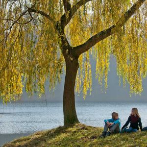
Picknick am Ulmener Maar © Natur- und Geopark Vulkaneifel GmbH, Kappest
-
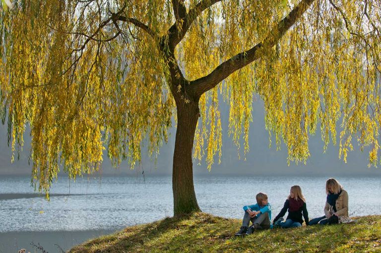
Maare und Thermen-Pfad am Ulmener Maar © Eifel Tourismus GmbH, D. Ketz
Geology
The eruption must have taken place in a warm period of the late or postglacial, as plant remains were found at the base of the Ulmen Maar ash. The ash fan can still be detected on the surface up to 600 meters to the southwest. The ash thickness ranges from 15 meters directly at the crater rim (almost complete tuff wall) to 0.2 millimeters in the Meerfelder Maar, around 20 kilometers away. The maar lies exactly on a SE-NW fault in the basement. To the southwest of it are Lower Devonian, gray-green sandstones and siltstones - partly quartzite - of the Reudelsterz layers, to the northeast is the Lower Devonian, unstructured elm step with sandstones, siltstones and shales. Maartuffs cover the Lower Devonian.
Worth knowing
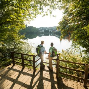
The view from the crater rim over the maar and the Eifel behind it is breathtaking. No matter how tempting the blue of the Ulmen Maar shines in summer, we are in a nature and water protection area and swimming is strictly forbidden here. But you can enjoy the good air while fishing for pike and carp. Maybe you can even see the huge fish that an old legend tells about. It is said that he was always seen when one of the lords of the castle died. We also recommend a detour up to the medieval castle ruins on the southern edge of the wall. Crusaders once marched from here to their battles in the 11th century. Since 1926, the Cochem-Zell district waterworks has been obtaining drinking water from the 39 m deep Maarsee using eight wells. Around 30,000 residents benefit from the 700,000 cubic meters of drinking water produced annually.
Highlights nearby
- Jungferweiher
- Ulmener Castle Ruins
- Eifel View Kreuzberg
- Eifel View Höchstberg
- Celtic Wall Steineberg
The Ulmener Maar is point 18 of the German Vocano Road.
Hiking trails
around the Ulmener Maar
Ulmen itself offers a picturesque picture and a tour around the Ulmener Maar is always worth it. The evidence of volcanism that can be admired here is impressive for laypeople and geologists alike.
-

-

HeimatSpuren Ulmener Acht
Rundweg nördlich und südlich von Ulmen, über Meiserich und die Auderather Mühle
- Schwierigkeitsgrad:

- Strecke: 21 km -
- Dauer: 6 Std.
- Aufstieg: 220 hm -
- Abstieg: 246 hm
- Schwierigkeitsgrad:
-

Entlang von Lieser, Endert und Salm Im Tal der wilden Endert
Deutschlands Schönster Wanderweg 2019 - Platz 1!
- Schwierigkeitsgrad:
- Strecke: 21 km -
- Dauer: 6:15 Std.
- Aufstieg: 78 hm -
- Abstieg: 414 hm
- Schwierigkeitsgrad:
Guided tours around the Ulmener Maar
- Eine Zeitreise – von „Alt nach Jung“ durchs Mittelalter
- Abenteuer Vulkanismus – Das Ulmener Maar und sein Maar-Stollen – Naturerlebnisspaziergang
- Sonntagsreihe: Jungferweiher in Ulmen
- Sonntagsreihe: Ulmener Maar
- Ulmen – Maare, Stollen und Burg perfekt vereint
- Abenteuer Vulkanismus – Jungferweiher mit Maar-Stollen zum Ulmener Maar– Naturerlebnisspaziergang
Directions & Parking
There are numerous signposted parking spaces in Ulmen, for example at the Alter Postplatz or at the market square in the center of Ulmen. From here it's just a short walk to the maar or to the lava wall.